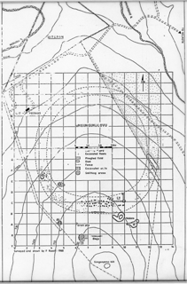
Site map of uMgungundlovu( Visual Item)
Attached files

Type
GeoTIFF
Caption
Site map of uMgungundlovu (Roodt 1993 fig 19).
File
uMgsiteplan_0011.tif

Type
Image
Caption
Site map of uMgungundlovu (Roodt 1993 fig 19).
File
30128ef948fa4b5b9a09b025f62575f1.jpg
Description
Fig. 19 from Frans Roodt's Masters thesis ''n rekonstructie van geelkoperbewerking by Mgungundlovu' (1993). The map was drawn by Frans Roodt and the location of the original map is currently unknown.
Type
Visual Item
Held by
Provenance
The original thesis resides in the libraries of the University of Pretoria.
Spatial relationships
- Falls within Map sheet 2831AD (Visual Item)
- Contains uMgungundlovu (Place)
- Contains No title (Human-Made Object)
- Contains Isigodlo area, section A (Visual Item)
- Contains Hut 7 (Visual Item)
- Contains Hut 11 (brewery hut) (Visual Item)
Makes connections with
- documents uMgungundlovu (History: From the Ntonjaneni Sprin…)
Archival Status